Yup, you heard it correctly, the recently acquired @Last team has worked with Google to produce a free version of their very popular 3D architecture and landscape program, SketchUp. (FREE download Here) As of now, SketchUp is the most commonly used program to create 3D models to be placed in Google Earth.
The free Google SketchUp version is windows only. There is also a Pro version which can be purchased for $495. This is much more like the original and at the original SketchUp price.
SO what are the new features!? Well, the Free version appears to have a similar tool selection as the original without some features like realtime shadow modeling and, most noteably, the ability to export in formates other than the Google 3D warehouse. What? Did you say Google 3D warehouse?
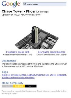
Yes, there is a new Kml housing format called a 3D warehouse. Although my download has not completed yet, I have messed with it a little from a link on the ogle earth blog. Save your models to a 3D warehouse and when put on a server, you point people to a 3D warehouse network link, much like a KMZ. When the link is opened in Google Earth, the Places menu will display the locations of the 3D models. Also, on the virtual globe itself, a
The models are not directly downloaded with the 3D warehouse network link. By clicking on a model name/location in the Places menu or clicking on the

On this popup, details such as model name, size, and complexity are given. Also TAGS!!! Yes, Google has employed tags into the models. Let the Metaverse begin!!!! From here, you may download the model to either Google Earth of Google Sketchup.
At this moment, textures are still not supported in Google Earth. I suspect, as well as many others, that this will change soon.
Here is a list of features the separate the Pro version from the Free version:
| Print and export raster images at higher-than-screen resolution. | ||
| Access to the following 3D export formats: DWG, DXF, 3DS, OBJ, XSI, VRML and FBX. | ||
| Export animations and walkthroughs as MOV (Mac) or AVI (Windows) files. | ||
| Use the Sandbox Tools (for organic modeling of terrain, etc) and the Film & Stage Tools (for pre-viz work). | ||
| Have access to free email tech support for two years from purchase. |
This story has been scooped this morning on a number of other blogs (Cartography, Google Earth Blog, All Points Blog, ogle Earth). Get out there and make some models!!!!
No comments:
Post a Comment