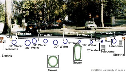
Much to the appreciation of UK archaeologists, a new program entitled VISTA (Visualizing integrated information on buried assets to reduce streetworks) aims to map the roughly 1.5 million kilometers of gas, sewer, water, and electricity utilities now in place under the their streets. With a significant portion of these conduits being nearly 200 years old, current knowledge of their whereabouts is sketchy at best (diagram below shows the complexity of utilities). Nottingham and Leeds University based researchers are leading a project team, including a number of archaeologists and ex-archaeologists (information gathered from the ARCHCOMP-L listserv), in a test case study at 6 locations within the UK.
This project aims to drastically decrease the number of holes dug to find long lost utilities, increase the response time to fixing utilities, and nullify the reported 30 – 40 injuries per year caused by accidentally digging into electrical lines. Using Ground Penetrating Radar (GPR), Global Positioning Systems (GPS), and pseudolites (essentially ground based GPS satellites) researchers will strive for centimeter accuracy.
The idealized product from this mapping effort is a 3D rendered data set of the entire utility system that can be served to linemen in the field on handheld units. From these handhelds, field crews can visualize the entire network under their feet and avoid costly or dangerous impacts.
Archaeologist in the UK would be very well served by knowing the precise location of such utilities. With the appropriate data in place, archaeologists would not only be safer, but would dig fewer disturbed contexts, and foster analysis through knowledge of construction fill locations and dates which utilities were laid.
Check out this article at BBC news for more info.
No comments:
Post a Comment