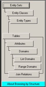
First, take a look at the data structure of the SDSFIE. The hierarchy starts with the "Entity Sets" which houses numerous "Entity Classes", down to "Entity Types", which contain "Attribute Tables", defined by "Domain Tables". To put this in ESRI lingo:
Entity Classes = Feature Data Sets
Entity Types + Attribute Tables = Feature Classes
The SDSFIE comes prebuilt with a host of Entity elements in place. Generally, these are Entity sets, types, and classes that the DoD felt useful in organizing their facilities and structures, but they are not exclusive to the military. There are a total of 26 Entity Sets, 185 Classes, and 1,122 Types as of the most recent SDSFIE release (2.5). The Sets include Buildings, Geology, Ecology, Communications, and Cultural. I will demonstrate an example using the Cultural Entity Set in a moment. From these sets, the classes and types become more specific.
 The Browsers are used to browse the data structure to find attributes and relationships. The Filter Maker is used to create a filter of the data structure for fast and efficient database creation. The Builders/Generator are used to create the database, using filters or manually, for a given application. And the Loader is used for data entry. Also handy is the web based Browser and Filter maker. Use this to take a walk through the data structure.
Here is a quick example using archaeology:
Entity Set: cultural
Entity Class: cultural_archaeological
Entity Type: archaeological_artifact_point
Table: crarcart
Discriminant Domain: art_type_d
Domain Values: "Fire_Rock", "General", "Unknown"
The table "crarcart" is used to locate and define "Objects or archaeological significance which, due to their size or nature, have not been removed from the site." In an implementation of the SDSFIE, this table would be used in relation to classes representing archaeological sites, testing areas, sensitive areas, cleared areas, and installations.
Creating filters and GDBs takes a little getting used to, but fortunately, there is a free online "Basic Training" available. This consists of 15 short courses which culminate in a quiz and a printable certificate of completion.
No comments:
Post a Comment