Launched Thursday night, Google Local is now including map icons to draw attention to a small set of advertiser in the new Local Business Ads program. The advertisers icons, once clicked, display sponsored link information including address, phone number, and a jpg logo.
A Search for "Ralph Lauren NY" turns up an example of this new ad technique (is that the ICQ chat icon?). According to an article at CNET, the ad icons will not be included in Google Maps accessing the API.
Friday, March 31, 2006
Wednesday, March 29, 2006
PerryGeo: Top 10 WMS list
As blogged at SlashGeo, check out the top ten list of WMS (Web Mapping Services) layers over at the PerryGEO blog.
The 10 WMS layers compiled my Matt Perry are a set of key base layers that can be pulled together in a web mapping interface such as MapServer, BeeldBlab, OpenJUMP, ArcIMS.
Also, Matt's blog post includes tips on displaying data availability and a slick MapServer app with the included mapfile.
Check out the rest of PerryGEO for some great nuts and bolts GIS, including a way to script a KML to Shapefile converter!
GPS + Camera + Google Map = Fantastic Field Survey Tool
As reported on Digg.com (and subsequently Dugg all to heck), here is a very cool GPS + Camera combo project. Simple concept; take a camera that supports recording GPS coordinatess in the image Exif data(Exchangeable Image File = like metadata for pictures), hook it up to a GPS, write a script to process the results into XML, put it on a google map. Check out the examples at the creators site.
Although, the idea of a GPS enabled camera has been floating around for a while, this is the first time I have seen productive results in a method that is easily reproducible (thanks to IceBurn's sharing of his Exif data to XML Perl script). Such a technology would be a boom for many types of field survey. Particularly, this tool would be incredibly useful in Historic Resource survey. Unless you are using handheld field data loggers, you are probably heads-up digitizing your locational info from a paper map or even Geocoding addresses. Then, photos needs to be renamed from photologs and plugged into your GIS by any number of ways. With the locationally aware camera, metadata could be associated with each photo via the ability to include Exif data or the GPS units data logger. With a script similar to IceBurn's Perl script, your location and photographic data is one step away from production. I can already hear the client's giddy laughter as the click a link and up come a Google Map with the days survey results published within a half hour of completion.
Stop by IceBurn's liar to check out his Geo-Camera and the great examples he has posted.
Edit: After doing a little searching I found the Richo Pro G3 GPS Camera. Including CF WAAS GPS, Bluetooth, and ESRI ArcGIS software to take care of all the dirty work. Very cool!
Monday, March 27, 2006
Conversions and 3D visualization on the Cheap
Within most GIS projects, particularly when 3D visualization is involved, divergent data sources and formats need to be brought together into a single product (Quickly and Cheaply). As an aid in figuring out how I was going to get data from one visualization platform to another, I created a simple chart that reminded me what went where. As I am sure there are more productive work arounds than listed here, I would be more than interested to hear from any readers who have suggestions.
 click image for larger view
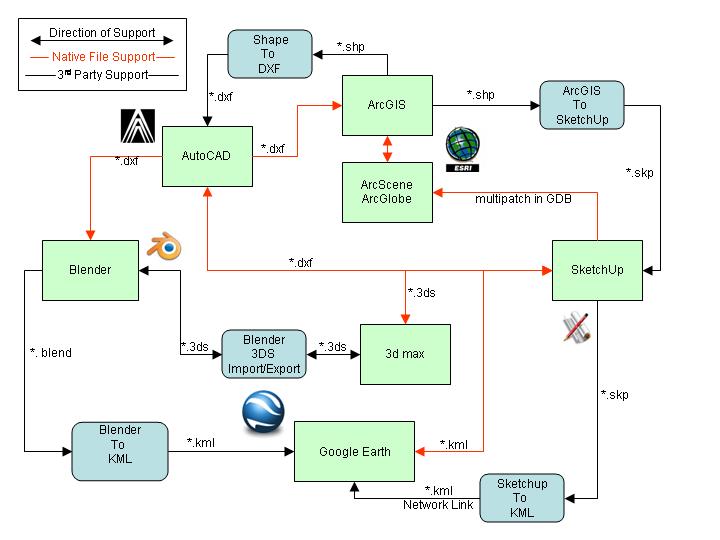 click image for larger view
3D Studio Max
ArcGIS
ArcScene/ArcGlobe
AutoCAD
Blender - Open Source
Google Earth - Open Source
Sketchup
DXF Author (ESRI Shapefile to DXF) - Open Source
Shapefile to Sketchup - Open Source
Blender 3DS Import/Export - Open Source
Blender to KML - Open Source
Sketchup to KML - Open Source
*Please note: I do not endorse these products. I am in no way affiliated with any of these products. I use this software for my day to day work and I though someone may get use out of this information.
Sunday, March 26, 2006
Location Technologies and Archaeology Sites
map loading...
The best and the worst thing about archaeology sites is location. Knowing the location of a site or multiple sites can help create models to find more sites and/or better understand what we know about a site. At the same time, archaeological site location is highly secure data. This is for the sites protection. There is a lot of money to be made on archaeological artifacts.
Here is the location of my favorite archaeological site. I may be breaking a rule by showing this, but it doesn't really matter. Since, Google Maps is living in the past, you wouldn't know that this site is now covered in dozens of high density housing units. Any potential scavengers would find nothing here except golf balls the folks shanked them.
I guess my point is, to me, archaeological sites are much more than just a point on the landscape that has artifacts buried in the dirt. Each is a place. Each has a personality, a view, a feel. There are numerous websites popping up lately that integrate places and commentary. Platial "The Collaborative Atlas", for example, is well known. It would be ideal to share with people the places I love and why feel that way about them. Beyond that, archaeological sites are a part of a town, state, county's heritage that belongs to everyone, not just a privileged few. Archaeological sites deserve to be part of an atlas. With people opening up their minds to spatial thinking and taking in new aspects of the environment, I would argue that archaeological information would be of interest. Anything to get people interested in archaeology should be pursued
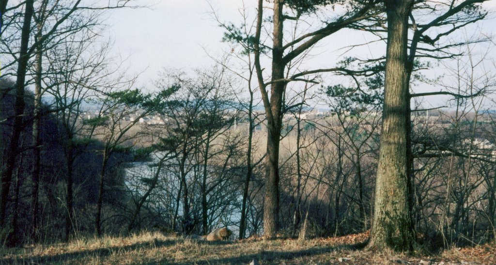
This is a pretty big topic in American archaeology. We want everyone to enjoy and learn from these sites. We preach that they belong to everyone and that justifies why we spend money to excavated them. But we secret them away because the integrity and intactness of the sites is the key to being valuable. So in the end, I can only show this place because it is gone.
Subscribe to:
Posts (Atom)